Want to hike to a historic fire lookout that offers incredible views of a sprawling turquoise lake, rolling hills of evergreen forests, and, best of all, Mount Rainier towering 14,411 feet above? Tolmie Peak Fire Lookout offers all this- and so much more.
So if you’re headed to Washington state’s Mount Rainier National Park and looking for an epic trail, let’s put your hiking boots to good use- here’s everything you need to know to hike to the Tolmie Peak Fire Lookout.
This post may contain affiliate links. If you make a purchase through them, we may receive a small commission, for which we are extremely grateful, at no extra cost to you.

")
Psssst… heading to Mount Rainier National Park? You may want to check out our other posts about some of the other amazing hikes in the park:
- 11 Best Mount Rainier Hikes
- Skyline Trail in Mount Rainier National Park
- Fremont Lookout in Mount Rainier
- Fall Hikes in Mount Rainier
IMPORTANT UPDATE AS OF MAY 2026: The Carbon River Fairfax Bridge has been closed by the Washington Department of Transportation, rendering the Tolmie Peak trailhead inaccessible at this time. Keep a look out on the Mount Rainier website for further updates.
What is Tolmie Peak Fire Lookout?
Fire lookouts are scattered throughout the moody mountaintops of the Pacific Northwest. These structures were originally built to do exactly what they sound like- help rangers and volunteers have a better vantage point to keep an eye out for forest fires below.
Most lookouts were built from the 1920s to the 1950s- Tolmie Peak (and the other three lookouts, including Mount Fremont, Gobbler’s Knob, and Suntop, that are in Mount Rainier National Park) were all constructed between 1932 and 1934.
Thanks to advances in technology, fire lookouts are largely obsolete these days- in fact, they’ve dwindled in number from the 750 structures that once topped Washington’s mountains to just 93 that remain today, like High Rock Lookout, Park Butte Lookout, and Heybrook Lookout, to name a few.
Even though they may not be used to stop forest fires any longer, they’re nonetheless still loved today by adventurers (and all the Instagram influencers) for their rustic charm and epic views. In fact, Tolmie Peak Fire Lookout was placed on the National Register of Historic Places in 1991 and has been a favorite of Rainier visitors ever since.

How to get to the Tolmie Peak Fire Lookout
Tolmie Peak Fire Lookout is located in the northwest corner of Mount Rainier National Park through the Mowich Lake Entrance, approximately 70 miles southeast of Seattle. I trust you know how to plug the trailhead into your favorite GPS app, but there’s a couple things you should know before heading here:
- In order to get to the trailhead, you’ll need to drive on a poorly-maintained 17-mile gravel road that’s full of gnarly potholes and pointy rocks looking to stab a hole in your car’s tires. As such, I would strongly advise either driving here only if you have a high clearance vehicle or you’re okay accepting the risk of getting a flat tire along the way (cell signal is spotty, at best, so, if you go for the latter option, be sure you know how to change a tire without assistance!).
My husband, Justin, and I actually attempted to drive here (twice!) with our tiny Prius-C and turned around because we were too nervous about popping a tire. But, with our new-to-us SUV, we were able to make it no problem (take that, crappy road)!

- Along the road, you’ll pass a sign demarcating your entrance into the national park. Approximately 4.5 miles in from here, you’ll pass a fee station on the right hand side, where you’ll need to stop, fill out an envelope, and pay the $30 entrance fee for the park if you don’t have an annual interagency pass, like America the Beautiful Pass, or a Mt. Rainier Pass. If you have either of these, feel free to keep driving past the fee station, so long as you make sure to display your pass on your dashboard.
- Due to the heavy snowfall the park receives, the road, starting at the gate for the park’s boundary, closes at the first snowfall the park receives, and doesn’t reopen usually until early to mid-July, when the snow has melted.
Outside of this season, you’ll be unable to reach the trailhead, unless you want to make the additional 10-mile round trip hike from the closed gate. In fact, even if you head here at the beginning of October, I’d recommend checking All Trails for recent user reports regarding whether the road is still open (or giving the Carbon River Ranger Station a call at (360) 829-9639).
Assuming you make it past the demon potholes and the apocalyptic level of snow on the road, congratulations- you’ve reached the trailhead to Tolmie Peak!
What to expect along the hike to Tolmie Peak Fire Lookout
To reach the Tolmie Peak Fire Lookout, you’ll need to follow the 6.5-mile (out-and-back) moderately challenging trail, called the Tolmie Peak Trail, through an old-growth forest and eventually summit (you guessed it!) Tolmie Peak. Along the way, you’ll climb up-and-down several hills, ultimately gaining 1,540 feet of elevation gain.

From the Mowich Lake campground trailhead, you’ll start along the path and almost immediately run into a junction as you hit the Wonderland Trail, an epic 93-mile hike that circumnavigates the entire base of Rainier. Here, you’ll follow signs for Eunice Lake and Tolmie Peak and keep left.
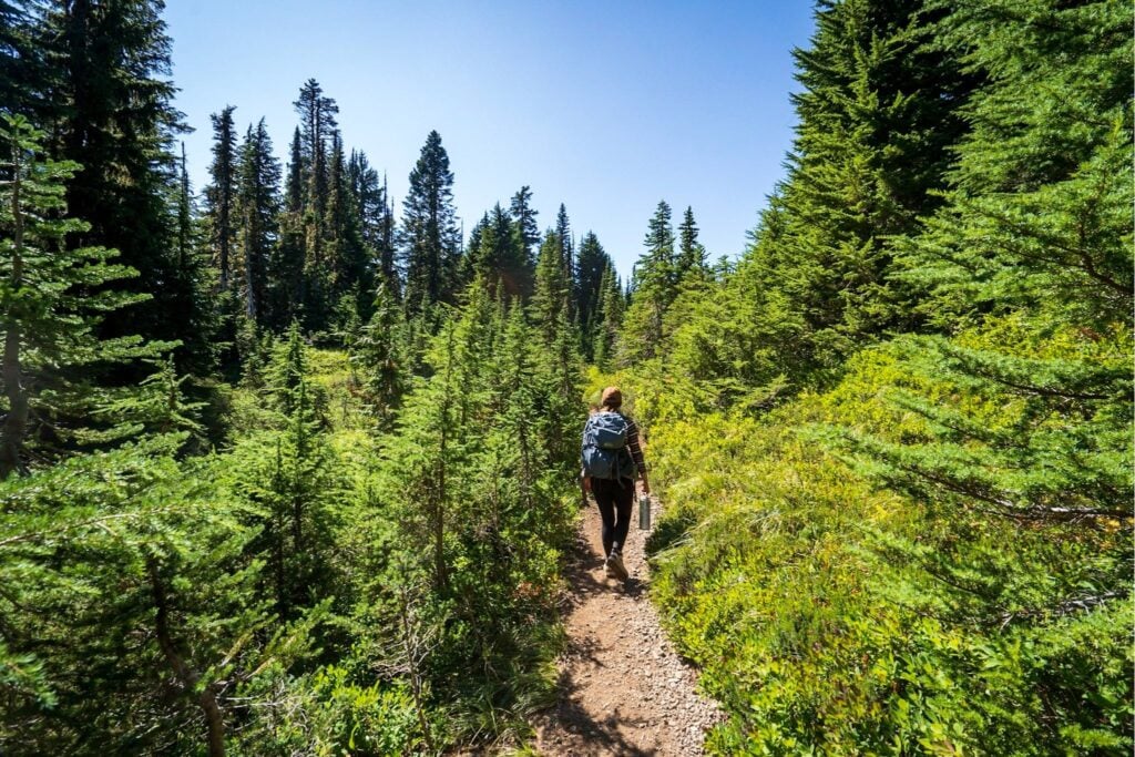
On your right, you’ll catch glimpses of the azure waters of Mowich Lake through the trees, as you skirt around the lake’s western shoreline. The elevation gain will at first be gradual, but it steadily becomes a thigh-of-steel-esque workout. On the plus side, impossibly grand fir, cedar, and hemlock trees form a cathedral over this initial part of the trail, providing blessed shade on a hot summer’s day.

Approximately one-mile in, you’ll reach yet another trail junction sign, with the sign pointing straight to Ipsut Pass. The signage here is confusing (and, because of this, I’d recommend downloading a trail map from AllTrails before you head here to make sure you stay on the right path), but you’ll take a left here, veering off the Wonderland Trail, and following the path downhill.
Pssst… you need the AllTrails+ version of the app to download offline maps, but luckily, our awesome readers can get a 7-day free trial PLUS 30% off your first year by using this link and the promo code "UPROOTED30" at check out.

If you're wondering whether the app is for you, we wrote a whole post on whether AllTrails+ is worth it.
You’ll continue on the path for 0.8 miles when you’ll hit- that’s right- a second stunning alpine lake called Eunice Lake (we are in the dreamland of Washington, after all!). While the bugs can be a bit nasty here in July and August, this otherwise is a lovely spot to admire the insanely clear water of the lake and rest up for the final push to the top (and see if you can spot the teeny tiny fire lookout on the ridge above!).
This also is an excellent spot to see colorful wildflowers along Eunice Lake’s shoreline- friendly reminder to always follow the leave no trace principles during your visit, including avoiding stepping on any of the meadows of fragile wildflowers and picking up any waste from snacks you may have brought.

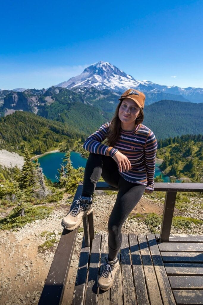
From the lake, you’ll follow four long switchbacks, totalling approximately one-mile, up to Tolmie Peak- while the elevation gain is killer, the sneak previews of the epic vistas of Rainier and the surrounding peaks along the way will surely serve as an excellent distraction. Once you reach the ridgeline, the trail curves to the north of Tolmie Peak, providing sweeping views of the Carbon River Valley below, before it spits you out by the fire lookout.
The in-your-face-views of Rainier are mind-blowing and on a clear day, you can see Mount St. Helens and layers upon layers of the Southern Cascade mountains. Of course, the fire lookout itself is worth a stop- it’s manned by volunteers most weekends in the summer, so you can check out the neato old-school devices, like the Osborne Fire Finder, that were once used by rangers to identify a wildfire’s bearings.
Before you retrace your steps back to the trailhead, there’s a 0.3-mile scramble past the fire lookout along a rocky ridgeline- there’s steep drop-offs, so only attempt this if you’re an experienced hiker (and not particularly scared of heights). We scrambled part of the way out- somehow, the views were even better!

When to hike to Tolmie Peak Fire Lookout
The vast majority of hikers enjoy the trail from mid-July through the beginning of October. July and August bring colorful wildflowers along the trail- as well as those nasty mosquitoes mentioned above.
For stunning fall colors, head here in late September and the first couple weeks of October- you’ll be treated to spectacular autumnal colors (provided the road is still open, of course). Not only do the leaves of the trees along Rainier’s valleys turn flaming shades of red and orange, but so do the wildflowers, shrubs, and succulents carpeting its rolling meadows and hills, making it one of the most spectacular fall hikes in Mount Rainier National Park.
Unfortunately, Tolmie Peak’s entire hiking season also happens to coincide with Washington’s wildfire season- so to be sure your views won’t be occluded with smoke, check this Fire and Smoke Map the morning of your hike, which shows current smoke plumes and the Air Quality Index of the Ashford area.

As noted above, you can still reach the trail in the wintertime, but you’ll have to snowshoe or cross-country ski approximately 10 miles round trip (with 1400 feet elevation gain) from the park’s gate to the trailhead. If you’re traveling via snowshoe, you can cut off one-mile of the hike to Mowich Lake by taking the Grindstone Trail approximately 2.5 miles from the gate, rather than following the road.
Note that winter hiking is a LOT more dangerous than summer hiking- you can’t see the trail or what’s under wherever you’re walking, and oh, yeah- did I mention avalanches? So only attempt this one if you’re an experienced adventurer and know what you’re doing!
As for what time of day to visit Tolmie Peak Fire Lookout, the views are stunning throughout the day, but sunset is particularly spectacular, with the setting golden sun casting spectacular colors on Rainier.

Which brings me to my next point…
Can you camp at Tolmie Peak Fire Lookout?
While you’re welcome to wake up at an ungodly hour to see sunrise from the fire lookout or hang out there after the last rays of the sun have eclipsed the horizon for the day, you’re not allowed to camp in or around Tolmie Peak Fire Lookout.
So instead, I’d recommend trying to snag a campsite at Mowich Lake Campground, a first-come, first-serve campground right by the trailhead (and did I mention it’s FREE?!). But apologies to my RV fam– this campground is walk-in only and just for tent campers.

What to pack for the Tolmie Peak Fire Lookout
Given that the hike to the Tolmie Peak Fire Lookout is pretty short, you won’t need too much gear, but here’s some things that will make your trip that much better:
Water:
With all of its ups and downs and steep elevation gain, this trail is a workout. Be sure to bring along plenty of water- I always carry one of these big Nalgene bottles on our hikes. Since they’re refillable, they’re better for the planet than plastic bottles- plus, they’re kinder to your wallet!
Sunscreen:
The first part of this trail is mostly in the shade, but once you reach the portion of the trail near Eunice Lake and beyond, you’ll be directly exposed to the sun, which can be quite intense at high elevation. So slather up with some sunscreen before hitting the trail- your non-wrinkled future self will thank me later.
Bear spray:
There are no grizzly bears in Mount Rainier National Park, but there are black bears that frequent this area. They are usually scared of humans and it’s fairly unlikely they’ll harm you, although mother black bears have been known to be aggressively protective around their young. Because of this risk, I take bear spray (which is used much like pepper spray to temporarily disorient, but not injure aggressive animals) with me wherever I go hiking in Washington state. Although we thankfully have never had to use it, we have this one.
Swimsuit:
If you’re visiting during the summer, there’s few things better after a long, sweaty hike than diving into Mowich Lake’s cool, blue waters. So don’t forget your swimsuit (like this one for women and this one for men)!
Offline maps:
Cell signal here sucks- be sure to download offline maps of the area and the trail on both the Google Maps and All Trails apps before you hit the road.
I’ve done a LOT of hikes in Mount Rainier National Park- and the one to Tolmie Peak Fire Lookout is undoubtedly one of my favorites. Is Tolmie Peak one of your favorites in the park? Let me know in the comments below.
Thank you for reading our post! Check out our latest stories here and follow us on Instagram (@JustinAndJess_), YouTube, TikTok, or on Facebook to see what we’re up to next!
