Glacier-capped peaks. A rustic fire lookout. Layers of mountains reaching to the horizon. Fremont Lookout provides all this- plus one of the best views of Mount Rainier that you can find in its national park. So if you’re headed on a Washington state road trip and planning a stop at Mount Rainier National Park, lace up those hiking boots and let’s hit the trail- here’s everything you need to know to hike to the Fremont Lookout.
This post may contain affiliate links. If you make a purchase through them, we may receive a small commission, for which we are extremely grateful, at no extra cost to you.

")
Psssst… heading to Mount Rainier National Park? You may want to check out our other posts about some of the other amazing hikes in the park:
- 10 Best Mount Rainier Hikes
- Skyline Trail in Mount Rainier
- Tolmie Peak Fire Lookout
- Fall Hikes in Mount Rainier
What is Fremont Lookout?
Fremont Lookout is a fire lookout, which functions exactly as it sounds. They’re wooden structures, perched on top of mountain peaks, that provide rangers and other volunteers a higher vantage point to watch for forest fires.
Washington state’s mountains used to be filthy with fire lookouts- 750, to be exact! But with the advances in fire technology rendering the lookouts largely obsolete, only 93 still remain today, including Park Butte Lookout, High Rock Lookout, Heybrook Lookout, and, of course, Fremont Lookout.
Fremont Lookout was built in 1933 and is one of four remaining lookouts in Mount Rainier National Park, along with Tolmie Peak, Gobblers Knob, and Suntop Lookouts. Fremont sits at over an eye-popping 7,000 feet of elevation, making it the highest one in the park.
And while it’s no longer used to spot forest fires, it’s in-your-face mountain views and historic charm still beckon hikers and other adventurers today. In fact, Fremont Lookout, along with its other Rainier lookout brethren, were placed on the National Register of Historic Places in 1991 and has become a beloved stalwart of the park today.

How to get to Fremont Lookout
Fremont Lookout is located a little over two hours southeast of Seattle in the northern side of the national park, called the Sunrise area, which is home to some of the best trails in the park, like the Burroughs Mountain Trail or the Summerland Trail.
You’ll actually enter the park on its east side through the White River entrance. Unless you have anannual interagency pass, like the America the Beautiful Pass, you’ll need to pay a $30 entrance fee per vehicle that’s good for up to a week.

For a few years, you were required to have a timed entry permit to get into Sunrise during the busy summer months, but that restriction has been lifted in 2026. So, if you’re visiting during the summer, I’d strongly recommend getting here early to ensure that you can snag a parking spot and to beat the massive crowds.
Unlike some of the trails in the Pacific Northwest, the roads to this trailhead are well-maintained and paved the entire way (fun fact: it’s the highest paved road in Washington!). Any passenger vehicle should have no issues making it.
Furthermore, the views along the way are worth the drive alone- along the scenic drive, you’ll get spectacular panoramic vistas of Rainier and its rolling wild-flower laden meadows.
However, there are a few quirky things you should know before making the drive:
Check for road closures
Due to this area’s high elevation and heavy snowfall, the roads here go through some funky closures. Starting in late September, Sunrise Park Road (the road you need to take for the last 10 miles to the trailhead) closes nightly and reopens each morning so long as the weather isn’t nasty.
Starting in mid-October (or the first heavy snowfall), the road to Sunrise is closed to vehicles at SR-410 (about 16 miles from the trailhead) through late June or early July each year. So before you head here in late September or early October, I’d recommend giving the White River Wilderness Center a call at (360) 569-6670 to confirm whether the road is still open for the year.
And, ultimately, unless you’re looking to take a 26+ mile hike, I’d recommend timing your visit from July through September.
You cannot take oversized vehicles on Sunrise Park Road
Word to the wise to my RVing fam: due to the tight switchbacks along the road, RVs and vehicles with trailers that exceed 25 feet in total length should not drive on the Sunrise Park Road itself (which, as mentioned above, constitutes the last 10 miles to the trailhead).

So if you can swing it, drop off your RV somewhere first (like, for example, at the nearby White River Campground) and get to the trailhead by a standard passenger vehicle.
What to expect along Mount Fremont Lookout Trail
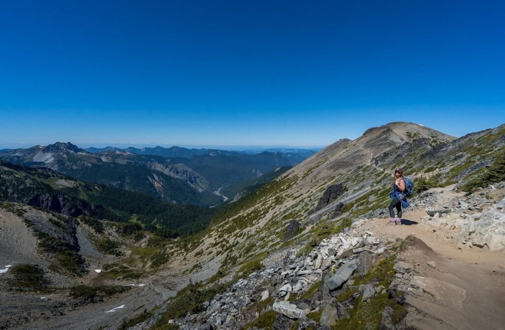
Once you reach the trailhead, it’s time to put those hiking boots to work! To get to the fire lookout, you’ll take the 5.7-mile (out-and-back) moderately challenging trail, called Mount Fremont Lookout Trail, and gain 1,118 feet of elevation in two big pushes, one towards the start of the hike and one towards the end.
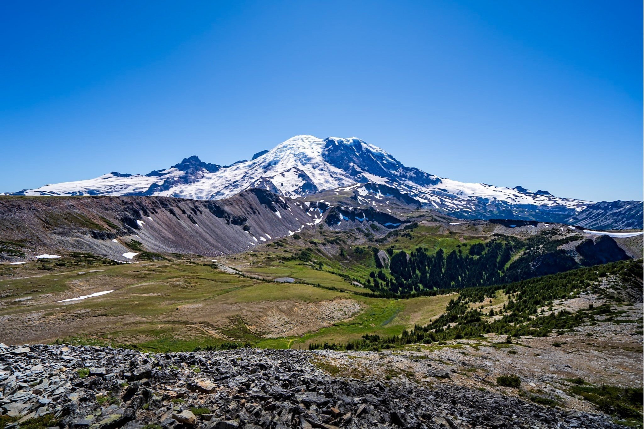
You’ll start behind the Sunrise Visitor’s Center on a steep climb along the Sunrise Ridge Access Trail. Just 0.2 miles in, the access trail will fork- keep to the left and continue your climb to the Sourdough Ridge Trail. Keep left again when you hit the Sourdogh Ridge and be sure to pause along the ridgeline and admire the stunning views of the layers upon layers of Cascade Mountains to your right.

The trail will fork once again at approximately 0.8 miles in (so. many. trail. junctions.)- sticking with our trend here, keep left to stay along the Sourdough Ridge Trail. Here, the trail will flatten out quite a bit as you make your way towards the stunning Frozen Lake, a small icy lake set against Rainier’s rolling hills.
At 1.5 miles in, you’ll hit yet another junction for several trails, Burroughs Mountain, the Wonderland Trail, and the one you’re looking for, Mt. Fremont. Follow signs to the right towards Mt. Fremont and you’ll notice a couple of things. For one, the crowds along the trail will dissipate quite a bit, allowing you to take in the sweeping views of Mount Rainier to your left in peace. For another, the terrain will switch from grassy meadows to jagged pieces of broken rocks.
You’ll follow this trail for another 1.3 miles, climbing an additional 481 feet in elevation. Keep an eye out for mountain goats to your left throughout your climb; this area is a favorite locale for our furry friends to bask in the sun!
And finally, the trail will spit you out at the summit of Mount Fremont, with the fire lookout in front of you, Rainier to your left, and seemingly the entire Cascade Mountain range to your right. Stop here, have a snack, and drink in the epic panoramic views. Word of caution- there’s a ton of super friendly chipmunks here who will be REAL excited about any kind of food you have (like aggressively excited- one crawled on top of my backpack!).
As always, follow the leave no trace principles, resist the urge to live out your Snow White fantasies, and don’t feed them!
Before you retrace your steps back to the trailhead, make sure to climb up the two-story fire lookout and have a look around. Volunteers man the lookout most weekends in the summertime so you can take a peek at the old timey tools the rangers used to use to identify the bearings of forest fires.
When to hike to Fremont Lookout
As mentioned above, it’s best to time your visit here from early to mid-July though the end of September, due to the heavy snowfall the area receives. The weather will be warm and sunny during this period and the ground blanketed by colorful wildflowers.

Unfortunately, Fremont Lookout’s entire hiking season also happens to coincide with Washington’s wildfire season. So to be sure your views won’t be occluded with smoke, check this Fire and Smoke Map the morning of your hike, which shows current smoke plumes and the Air Quality Index of the Sunrise area.
While bicyclists and hikers are welcome to climb along the road throughout the year, wintertime closures will add a minimum of 20 miles and a couple thousand feet elevation gain roundtrip to your trek (and did I mention there’d be a lot of snow?).
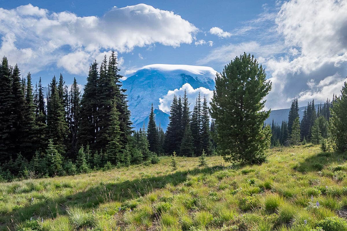
As to what time of day to do this hike, sunrise and sunset are particularly spectacular. In fact, due to its topography, this area is prone to experiencing cloud inversions (i.e., when warm air is trapped on the bottom, with cold air on top, creating an environment where clouds blanket the ground), which, if you’re lucky enough to catch one, make sunrise and sunset straight up EPIC here.

If I had to pick one, I’d recommend going for sunrise, sheerly due to the fact that this is a popular trail and you’re much more likely to have it to yourself if you wake up at an ungodly hour.
For either of these times of day, bring along your headlamp and be extremely careful along the trail. So if sunrise and sunset are so awesome here, can you just, like, camp out? Why, I’m so glad you asked!
Can you camp at Fremont Lookout?
Camping is not allowed in or near the Fremont Lookout. If you’re interested in hitting the trail super early or super late and want a place to sleep close by, you do have a couple camping options:
- You can snag a spot in the White River Campground, just a short drive down the road from Sunrise, with spots for RVs (RVs up to 27 feet and trailers up to 18 feet), as well as flush toilets and water.
- While you can’t backcountry camp near the lookout, there are some backpacking options reasonably close to it, like Sunrise Camp, Forest Lake, or Berkley Park. You’ll need to apply for a permit to go backpacking in Rainier- check out this guide for more information.

What to pack for Mount Fremont Lookout Trail
Given that the hike to Fremont Lookout is pretty short, you won’t need too much gear, but here’s some things that will make your trip that much better:
Water
Between the high elevation of the hike and the limited shade along the trail, you’ll need a decent amount of water for this hike. I always carry one of these big Nalgene bottles on our hikes. Since they’re refillable, they’re better for the planet than disposable plastic bottles- plus, they’re kinder to your wallet!
Sunscreen
A few sections of the hike are shaded but otherwise, you’ll be directly exposed to the sun almost the entire way, which can be quite intense at high elevation. So slather up with some sunscreen before hitting the trail- your non-wrinkled future self will thank me later.
Bear spray
There are no grizzly bears in Mount Rainier National Park, but there are black bears that frequent this area. They are usually scared of humans and it’s fairly unlikely they’ll harm you, although mother black bears have been known to be aggressively protective around their young.
Because of this risk, I take bear spray (which is used much like pepper spray to temporarily disorient, but not injure aggressive animals) with me wherever I go hiking in Washington state. Although we thankfully have never had to use it, we each carry this one.
Offline maps
Cell signal here can be spotty, at best- be sure to download offline maps of the area and the trail on both the Google Maps and AllTrails apps before you hit the road.
Pssst… you'll need the AllTrails+ version of the app to download offline maps. Luckily, you can get a 7-day free trial, PLUS our awesome readers get a sweet 30% off discount for their first year—just use the code “Uprooted30” at check out!

If you’ve been thinking about upgrading your AllTrails account to the paid version (I know it took me, like, five years to make the jump), we wrote a whole post about whether an AllTrails+ account is worth it.
Rainier has some incredibly stunning trails- but Fremont Lookout may just take the cake. How does Fremont Lookout compare to the hikes you’ve tried in Rainier? Let me know in the comments below!
Thank you for reading our post! Check out our latest stories here and follow us on Instagram (@JustinAndJess_), YouTube, TikTok, or on Facebook to see what we’re up to next!
