Lake Tahoe is an alpine wonderland, with snow-capped mountain peaks, dense pine tree forests, and, of course, the lake’s iconically blue, crystal clear waters. One of the best hikes to enjoy this incredible landscape is the Rubicon Trail, which leads you along the lake’s stunning shoreline, past dramatic cliffs, hidden coves, and stellar mountain views. Here’s everything you need to know about the Rubicon Trail, the best day hike in Lake Tahoe.
This post may contain affiliate links. If you make a purchase through them, we may receive a small commission, for which we are extremely grateful, at no extra cost to you.

")
About the Rubicon Trail
- Length: 9 miles
- Elevation gain:1,020 ft
- Difficulty: Moderate
- Fees? It costs $10 to park at Emerald Bay State Park or D.L. Bliss State Park.
- Are dogs allowed? Sadly, you’ll need to leave your furbaby at home for this one.
- Trail map

What is the Rubicon Trail?
When my husband, Justin, and I visited this area, I kept hearing that the Rubicon Trail was one of the very best hikes in Lake Tahoe, so naturally, we HAD to do it.
However, the information I found online was SO confusing. Each website seemed to list wildly different starting points, endpoints and lengths (like, some articles I found indicated that this trail is over 18 miles long!).

The reason for the confusion is that there’s actually a couple of different trails in the area that are referred to as the Rubicon Trail—either the moderate hiking trail along the banks of Lake Tahoe, from Emerald Bay to D.L. Bliss State Park, or an 18.2 mile trail for off-highway vehicles that cuts through the Sierra Nevadas from Loon Lake to the banks of Lake Tahoe in the town of Chamberlands Estates.
While the offroading trail indeed sounds pretty epic, we’re going to instead be focusing on the Rubicon hiking trail in this article.
How to Get to the Rubicon Trail
The Rubicon Trail stretches along the southwestern shores of Lake Tahoe, from Emerald Bay State Park to D.L. Bliss State Park.
Each of these parks are located in South Lake Tahoe, California and can be reached by driving approximately half an hour west of the town’s downtown area. It costs $10 to park at either of the parks for the day.
There’s a lot of conflicting information online about where the trail “officially” starts and ends.
Technically, I believe the trail was recently extended past Vikingsholm, an AMAZING 19th century Scandinavian Castle on the banks of Lake Tahoe, to start at the Upper Eagle Point Campground in Emerald Bay State Park (which would make this around a 13-mile hike).

For the purposes of this article, though, we’re going to treat the Vikingsholm parking lot in Emerald Bay, located here, as the trailhead and Rubicon Point in D.L. State Park, located here, as the endpoint. This is one of the most popular ways to hike the Rubicon Trail—and the way that Justin and I hiked it.
In most years, you can park at either of the parks and use that as the trailhead for the Rubicon Trail (or even park a vehicle at each state park and hike it as a point-to-point trail!). However, D. L. Bliss State Park is actually closed to motorized vehicles and foot traffic in 2023, due to a water infrastructure project. Accordingly, you’ll need to park at Emerald Bay State Park and start from there.
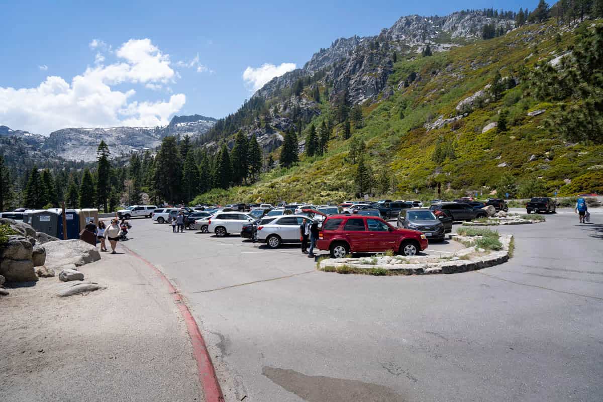
Emerald Bay State Park is one of the best things to do in Northern California and accordingly, is quite POPULAR, not only for hiking, but also for its beach, as a kayaking or stand-up paddleboarding launch point, and even for tourists eager to tour the storied halls of Vikingsholm.
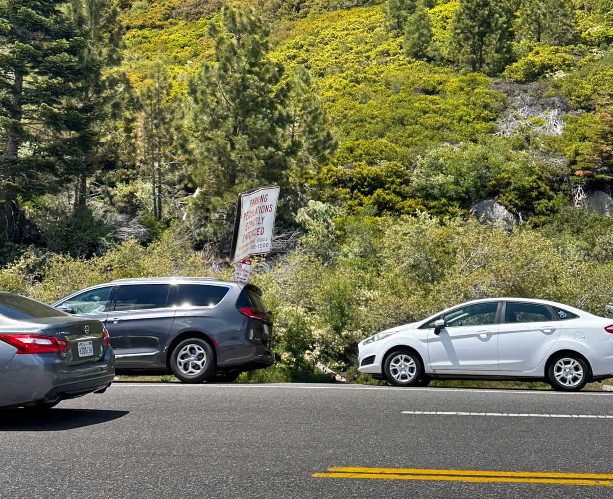
All that is to say—the parking lot at Emerald Bay fills up quite early and leaving your car on the very narrow shoulder of the road outside of the lot is prohibited. By the time we were leaving Emerald Bay from our hike, we saw HUNDREDS of cars parked outside of the lot and a police officer methodically moving down the line, giving out tickets.
So get here bright and early (ideally, before 9 AM, especially if you’re visiting on a weekend) to make sure you can snag a spot inside the actual lot—getting a ticket (or having your car hit, due to being parked on a narrow shoulder!) would definitely be a bummer when you’re someplace as beautiful as Tahoe.
What to Expect Along the Rubicon Trail
Starting from the Vikingsholm parking lot in Emerald Bay, you’ll walk down a series of steep switchbacks, dropping 500 feet in half a mile, to reach the lakeshore.
While heading downhill isn’t so bad, just remember that, when it comes to hiking, whatever goes down, must come up! So be sure to save plenty of water to make the climb back to the parking lot at the end of your hike—Justin and I each have one of these comically giant Nalgene bottles that we take with us one all of our hikes.
When you reach the bottom of the hill, you can take a peek around to see Emerald Bay’s beautiful beach or the absolutely stunning architecture of Vikingsholm. Once you’re ready to hit the trail, though, you’ll find a wide pathway, running parallel to the lakeshore before the beach area with a “Rubicon Trailhead” sign.

Turn left here and the trail will start to lead you around the north side of Emerald Bay. Be sure to glance to your right hand side—Emerald Bay is home to Fannette Island, the only island in all of Lake Tahoe.
The trail is fairly flat for approximately a mile and a half, skirting right along the lakeshore and passing secluded coves and absolutely breathtaking views of the lake and the surrounding Sierras.
About 1.6 miles in, you’ll start climbing up the dusty trail, which will lead you a bit deeper into the surrounding pine tree forests, temporarily obscuring your views of the lake.
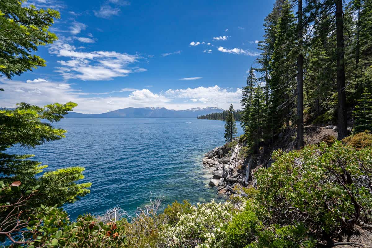
As you approach D.L. Bliss State Park, the trail will meander back to the lakeshore and the trail will slope downward again, with dramatic cliffside views of the turquoise waters below.
Before hiking this trail, I was curious whether the scenery was going to get a bit boring, given that the majority of the hike is along the lakeshore—but, given that the trail is constantly transitioning from offering expansive views high above the lake, with mountain vistas, to right along the banks of the sparkling water, I promise you’ll never get bored!

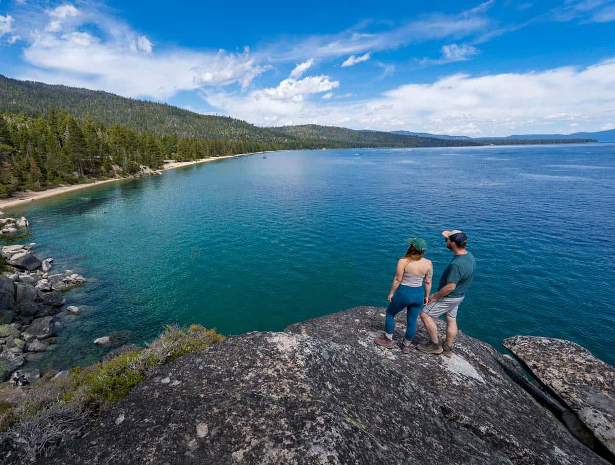
Approximately 2.4 miles into the trail, the path will fork, with the left pathway leading you up the Old Lighthouse and the park’s campgrounds and the right one taking you to Rubicon Point. This is a cluster of enormous rocks overlooking Lester Beach, the impossibly blue waters of Tahoe, and beyond, the snowy caps of the Sierra Nevada.
You’ll have to scramble to the top of the rock formation, but once you get up there, it’s a great place to take a breather and soak in the views. Justin and I spent probably around an hour, enjoying our lunch and the stellar views around us here.
When you’re ready to head back, simply retrace your steps back to the trailhead—and psych yourself up for your final ascent back to the parking lot!
When to Visit the Rubicon Trail
Because of its high elevation, Lake Tahoe can receive epic amounts of snow in the wintertime, so the best time to hike the Rubicon Trail is between May and October, when the trail and roads here are snow- and ice-free.

If you’re a skier or snowboarder, Tahoe is one of the best places to visit California in winter. The Rubicon Trail, however, isn’t always the easiest to access in the colder months. Come winter, the gate to D.L. Bliss State Park is closed, the parking lots for Emerald Bay are unplowed, and Highway 89 is regularly closed due to snow.
If you happen to be visiting in the wintertime and the roads and parking lot are accessible, you can certainly still take on the Rubicon Trail, but I’d suggest reading the current trail conditions on AllTrails and bringing along microspikes (and possibly snowshoes—here’s the kind I have and here’s the kind Justin has)—just remember that certain areas of the trail are steep, which can be dangerous in icy weather!
Tips for the Rubicon Trail
Leave No Trace.
Areas of Tahoe, including Emerald Bay, are getting loved to death, so please remember to follow the Leave No Trace principles. Pack out whatever you pack in, follow any fire restrictions that are in place, and generally, leave the trail and these beautiful parks better than you found them.

Explore the state parks.
Make the most of being at one of the most beautiful lakes in the United States and explore beyond the trail itself.
For example, if you’re visiting on a particularly warm day, pack along a swimsuit and jump in the crystal clear water in one of the beautiful coves along the trail—just be prepared for it to be frosty! Alternatively, consider renting a stand-up paddleboard or kayak at Emerald Bay or going on a tour of the storied halls of Vikingsholm (tours are available from Memorial Day through the end of September).

There’s tons to see and do in this little slice of heaven, so be sure to take advantage of it!
Where to Stay in Lake Tahoe
Lake Tahoe is surprisingly large—with 72 miles of coastline, it would take three hours to drive around its shores.
Accordingly, it’s important to pick a convenient location to stay while you’re visiting Tahoe. South Lake Tahoe is personally my favorite, given that it’s a pretty cute town that’s conveniently located near some of the best attractions in both the California side of Tahoe, like the Rubicon Trail, and the Nevada side, like Sand Harbor.

Some of the best places to stay in Lake Tahoe are:
- Stardust Lodge: The Stardust Lounge is definitely on the retro side, but manages to feel charming, rather than rundown. This centrally located hotel has a cozy interior and offers a number of amenities, like two different pool areas and free continental breakfast every morning.
- Basecamp: If you’re looking for something a bit more hip and eclectic, Basecamp has a variety of options, ranging from a standard room with two queen beds to a family suite. Basecamp is home to my personal favorite brewery in South Lake Tahoe, South of North Brewing Company, and has tons of awesome perks, like a rooftop hot tub, lawn games, and even firepits where guests can make smores.
- The Landing Resort and Spa: The Landing is a more luxurious option, offering rooms with a gas fireplace and lake views. Here, you’ll find an onsite spa, to relax those aching muscles after the Rubicon Trail, a heated swimming pool and hot tub, and rooftop terrace to watch the sunset.
The Rubicon Trail is Lake Tahoe classic for a reason—enjoy! Do you have any questions about this trail? Let me know in the comments below!
Thank you for reading our post! Check out our latest stories here and follow us on Instagram (@UprootedTraveler), YouTube, or on Facebook to see what we’re up to next!
