Smith Rock State Park, located right outside of Bend, Oregon, is a high desert wonderland, with jagged basalt rock formations, dreamy pine tree forests, and the rushing waters of the Crooked River. One of the best ways to explore the park is on foot, via any one of its incredible hiking trails that wind through its stunning landscape. Here’s 5 unmissable Smith Rock hikes, so that you can enjoy the epic scenery for yourself!
This post may contain affiliate links. If you make a purchase through them, we may receive a small commission, for which we are extremely grateful, at no extra cost to you.
")
Best Smith Rock Hikes
One thing to note before diving into my favorite hikes in Smith Rock State Park—the park has a kind of quirky trail system, with lots of short trails (most of which are less than a mile long) that connect with one another and can be easily combined in an unlimited number of ways to create different loops or extended out-and-back trails.
On one hand, this is awesome—you have endless options of different trail combinations to explore and have the flexibility of figuring out a hike that’s right for you. On the other hand, given the variety of options, it can be a bit overwhelming to pick which trail or combination of trails you should choose.
While I’ve outlined some of the best hikes in the park to explore below, I’d suggest taking a look at the park’s trail map and seeing if there’s ways that you want to extend or customize the hikes even further. Smith Rock State Park is your oyster!

With that, let’s talk trails!
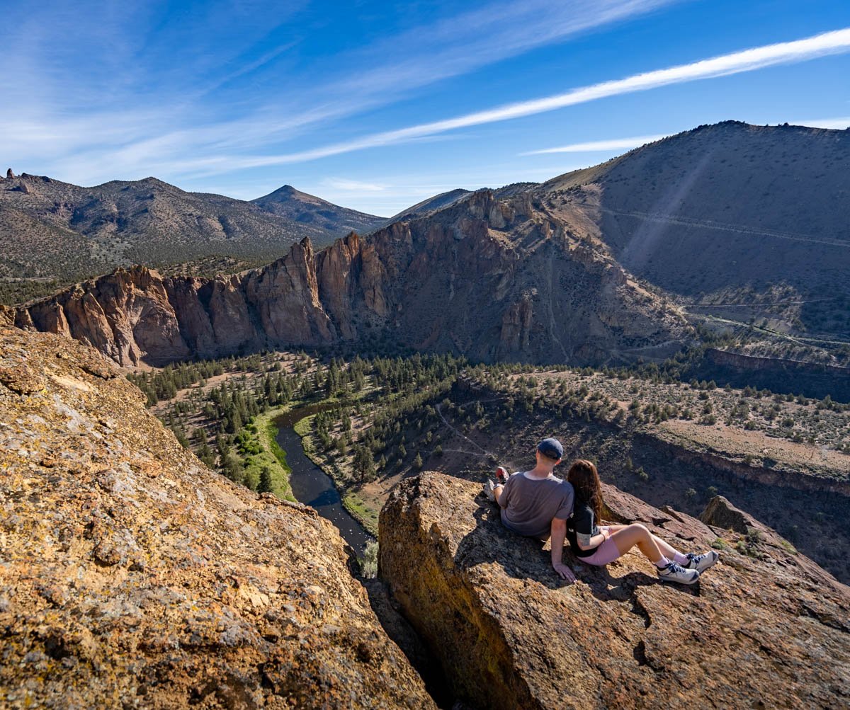
1. Misery Ridge Hike
- Distance: 2.2 miles
- Elevation gain: 1,115 feet
- Difficulty: Hard
If you’re only going to do one Smith Rock hike, be sure it’s this incredible doozy. While it’s definitely a bit of a butt-kicker (rising over 1,000 feet in just a mile!), the views at the top are nothing short of epic. It’ll be clear why Smith Rock is considered one of the 7 Wonders of Oregon, with the towering spires of the Monument area to the north, the famous Monkey Face rock formation to the west, and the Crooked River snaking across the landscape below.
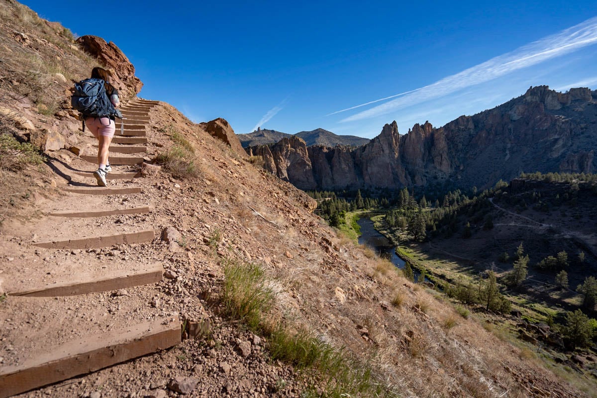
Just be sure to bring along some sunscreen and plenty of water–besides just having seemingly never-ending switchbacks to the endpoint, the trail is also almost totally exposed to the sun.
While many hikers choose to simply do this trail as an out-and-back hike, there’s actually several other trails that connect to it, if you want to make this into a longer trek. For example:
Misery Ridge and the River Trail
- Distance: 3.5 miles
- Elevation gain: 1,043 feet
- Difficulty: Hard
If you’re looking for the best extension of the Misery Ridge trail, this would be my pick, given it offers the iconic views over Smith Rock’s basalt formations, in addition to a pleasant and leisurely walk along the banks of the Crooked River.
For this loop trail, you’ll climb up the same steep switchbacks to the top of Misery Ridge and then turn left, descending down a series of switchbacks until you’re behind Monkey Face. The trail will eventually even out and you’ll loop back to the parking lot by following a flat and gently path alongside the rushing river. Keep an eye out for some cute ducks and even otters out in the water!

Misery Ridge and Summit Trail Loop
- Distance: 6.0 miles
- Elevation gain: 1,774 feet
- Difficulty: Hard
On this longer and more challenging iteration, you’ll turn right once your each the end of the Misery Ridge trail and continue to follow the Summit Trail along the northern boundary of the park. This route provides unique views of the park’s rocky spires and canyons; in fact, along part of the trail, you can basically see the whole main section of the park at a distance.

This option tends to be a lot less crowded than some of the other trails, so if you’re looking for a quiet place to enjoy Smith Rock, this may be a good one to check out!.
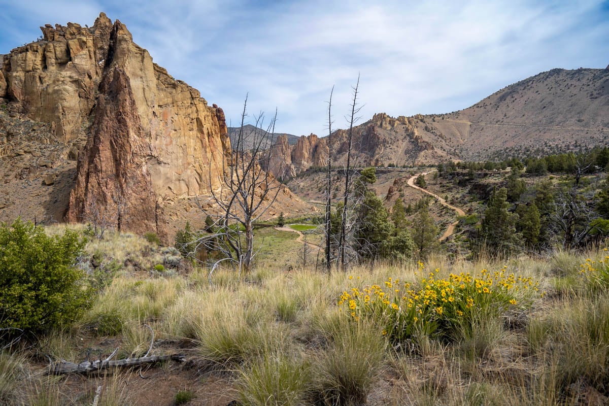
2. River Trail
- Distance: 2.5 miles
- Elevation gain: 200 feet
- Difficulty: Easy
If you’re looking for an easier Smith Rock hike than the Misery Ridge trail, consider checking out the family-friendly River Trail. True to its name, the path snakes along between the Crooked River and the canyon wall, taking you through fields of sagebrush, wildflowers, and pine tree forests along the way.

This hike is also one of the best places to spot wildlife in the park, like mule deer, beavers, or golden eagles. If all else fails, simply look up—you’re almost guaranteed to spot rock climbers scaling the canyon walls, hundreds of feet above you!
3. Canyon Trail
- Distance: 3.1 miles
- Elevation gain: 180 feet
- Difficulty: Easy
While the River Trail is the most popular easy hike at Smith Rock, the Canyon Trail, in my opinion, is the park’s best beginner trail.
It’s on the opposite side of the Crooked River as the River Trail, so you’re afforded a much better view of both the water and the towering walls themselves. Plus, in addition to following along the river’s banks, this trail snakes through a beautiful pine tree forest, so there’s a bit more diversity of the landscape that you’ll pass along the way.

It’s also usually WAY less crowded than the River Trail—when my husband, Justin, and I visited, I don’t think we passed another hiker on the entire trail (and we were visiting on a Saturday on Memorial Day weekend!).
If you’re looking to make this hike a bit longer and more challenging, I’d suggest hiking out-and-back along the Canyon Trail, then climbing over 300 feet along the Rope de Dope Trail (0.4 miles), and finishing out your hike by walking along the edge of the canyon along the Rim Rock Trail (described further below), back to your vehicle. On this loop, you’ll get to see a little bit of everything- forests, the river, Smith Rock’s iconic rock formations, and epic views from the rim of the canyon.
4. Wolf Tree Trail
- Distance: 2.7 miles
- Elevation gain: 406 feet
- Difficulty: Easy
While the River and Canyon Trails follow the Crooked River to the south, the Wolf Tree Trail instead follows the water northbound. Accordingly, in addition to providing views of the river, the Monument, one of the most dramatic rock formations in the park, will loom directly in front of you throughout the majority of your hike.

And like the other Smith Rock hikes along the river, you’ll likely see some cute (or not so cute) animal friends along the way—when Justin and I hiked here, we saw a rattlesnake directly on the trail (I’d say that one falls into the not-so-cute bucket)!
If you can get past the slithery creatures that live here, you can either treat this as an out-and-back trail and turn around once you pass the Monument or, alternatively, extend your hike along Burma Road Trail or even as part of a big ol’ loop along the Misery Ridge Trail
5. Rim Rock Trail
- Distance: 1.0 mile
- Elevation gain: 22 feet
- Difficulty: Easy
Finally—a trail that doesn’t follow along the river!
Instead, true to its name, this wide, gravel-packed trail curves along the rim of the canyon (and on the trail’s other side, the less picturesque parking lot), offering views down to the Crooked River and beyond, the Phoenix Buttress rock formation.

This is a great introductory hike to the park, as you’ll be able to enjoy views of all of its most iconic formations and it’s accessible to all kinds of hikers.
It also happens to be my favorite place in the park to watch the sun sink beneath the craggy rock spires for the day, as the sky lights up with punchy shades of pink and orange. If you’re going to watch sunset in the park (which you totally should), just don’t forget to bring along your headlamp so you can make it back to your car alright!
How to Get to Smith Rock State Park
Smith Rock State Park is located here, in the tiny town of Terrebonne in Central Oregon, about 40 minutes north of Bend or, alternatively, three hours southeast of Portland if you’re enjoying an Oregon road trip. It’s conveniently located right off Highway 97, so there’s smooth and paved roads the entire way there.
It costs $5 per vehicle to park here and if you can swing it, I’d suggest getting here early or in the early evening after the crowds have died down.

While there’s a decent amount of parking, Smith Rock is a POPULAR place to visit and on busy weekends and holidays, you may have to fight to the death for a parking spot here. During Justin’s and my last visit, there were multiple people jockeying for our parking spot by the time we left in the early afternoon!
When to Visit Smith Rock State Park
The best time to visit Smith Rock is in the spring and the fall, when temperatures are pleasant and the park is less chaotic than in the busy summer.
Beyond just being busy, given the park’s location in the high desert, it can get sweltering here in the summertime, with temperatures regularly exceeding 100 degrees.
The winter, on the other hand, can be quite chilly and the trails (and even roads around the park!) can receive snow and ice. If you’re visiting during this period of time, I’d suggest bringing along microspikes to help provide traction on the slick trails.
Frequently Asked Questions About Smith Rock State Park
How Long Does It Take to Visit Smith Rock State Park?
Smith Rock is actually a pretty small park, encompassing around just 650 acres—you could definitely see all of its highlights in just a day.
That being said, if you want to have a more chill time visiting, a weekend should be plenty of time to explore the park at your leisure.

Are dogs allowed on hikes at Smith Rock State Park?
Your furry best friend must be leashed and attended at all times (or you might face a $150 ticket) but otherwise they’re allowed in the park and on its trails.
What else is there to do at Smith Rock State Park?
I would be remiss to write an article about Smith Rock State Park and not address what its claim to fame is—rock climbing!
The dramatic basalt cliffs are actually considered the birthplace of sport climbing in the United States and the park is largely considered one of the best rock climbing destinations in the country. In fact, there’s almost TWO THOUSAND rock climbing routes in the park to enjoy!

If you’re an experienced climber, consider checking out some of the most popular routes, which include Morning Glory Wall, Monkey Face, Picnic Lunch Wall, and Red Wall. Alternatively, if you’re a beginner, you can go on a guided climbing tour, like Chockstone Climbing Guides or Smith Rock Climbing School.
What should I bring when hiking Smith Rock State Park?
- Sturdy hiking shoes, like this pair for men or this pair for women, to help provide traction on the rocky trails (especially Misery Ridge!)
- Sunscreen
- Plenty of water—many of the Smith Rock hikes are unshaded and, given the high desert landscape, it tends to be pretty hot and dry here. Both Justin and I have these comically enormous Nalgene bottles that we take along on hikes that keep us nice and hydrated.
- Cash or card to pay the parking fee

Where should I stay when visiting Smith Rock State Park?
I try not to play favorites with cities in Oregon, but I LOVE Bend, with 158 days of sunshine year round, lots of good breweries, and all of the outdoor adventures you could ask for, from the awesome Broken Top hike (one of my favorite hikes I’ve done EVER!) to floating down the Deschutes River. So if you have time, I’d strongly suggest adding on at least a few days in the charming town when you visit Smith Rock.
Consider staying at:
- Oxford Hotel Bend: Located in the heart of downtown Bend, the Oxford Hotel has seamlessly melded eco-friendly and natural design elements with a luxurious ambiance, with upscale amenities, like a hot tub and a fitness room overlooking the Cascade range, and super kind staff.
- Tetherow Hotel: If you’re looking for something a bit more quiet and relaxing, the Tetherow bring the same level of comfort and luxury as the Oxford Hotel, but on its own sprawling 700-acres of property (still just 10 minutes from downtown, though!). You’ll find everything you need here, from a swanky golf course and three restaurants to a sun terrace and a heated outdoor pool.
- Bunk + Brew Historic Lucas House: If you’re more of a budget traveler, consider this hostel, with both dorm and private rooms, which is housed in the oldest building in Bend. Beyond the beautiful historic construction, this place is just plain fun, with a food truck in its backyard and fun events, like ski movie night.
I hope you love the hikes in Smith Rock State Park as much as I do! Do you have any questions about the trails? Let me know in the comments below!
Thank you for reading our post! Check out our latest stories here and follow us on Instagram (@JustinAndJess_), YouTube, TikTok, or on Facebook to see what we’re up to next!
