Bryce Canyon National Park’s aptly-named Fairyland Loop Trail will take you below the rim of the canyon, while the park’s iconic pink and orange hoodoos tower overhead. And better yet? This trail is a hidden gem- you may just have it all to yourself!
So if you’re looking for one the best hikes in Bryce Canyon, look no further- here’s everything you need to know about the Fairyland Loop Trail.
This post may contain affiliate links. If you make a purchase through them, we may receive a small commission, for which we are extremely grateful, at no extra cost to you.

")
About the Fairyland Loop Trail
- Length: 7.8 miles
- Elevation gain: 1,545 feet
- Difficulty: Moderate
- Pet-friendly: Sadly, no- like most U.S. National Parks, dogs are not allowed on the trails at Bryce Canyon, so you’ll need to leave your furry best friend at home.

And before we dive into the rest of the article, we must address the elephant in the room…
What is a Hoodoo?
So what the heck is a hoodoo? I’m so glad you asked!
Hoodoos- also called “fairy chimneys” or “earth pyramids”- are rock spires, found only in a few select places on the planet, including Bryce Canyon and Cappadocia, Turkey (yes, that place with all the hot air balloons and the girls in the flying dresses you see all over Instagram). Hoodoos are so unique, because they require a very specific type of soft rock and weather to form over the course of millions and millions of years.

Although most people think of Bryce Canyon as a warm destination, it can get freezing- quite literally!- due to being located at a whopping eight to nine THOUSAND feet over sea level!. Over time, water seeps into its porous sedimentary rock and, on any of the 200 nights each year where it gets below freezing, the frozen water in the rocks’ joints expand.
Bit by bit, the rock cracks from this expansion and, coupled with erosion from rainwater, it’s shaped by this process over time. Eventually, these magical-looking formations are created, which now draw over 1.5 million visitors to Bryce Canyon every year!
Why is it called the Fairyland Loop?
The hike departs from Fairyland Point, which has a trail that descends into Fairyland Canyon. But, like…. why is the canyon named that?
“Fairyland” earns its name from the surrounding hoodoos, which have a whimsical or even supernatural-like feel to them. In fact, hoodoos are often-referred to as “fairy chimneys” in Cappadocia, Turkey. So ultimately, it’s called the Fairyland Loop, because, well, it feels like you’re walking through a fairyland!

How to Get to the Fairyland Loop Trail
Bryce Canyon National Park is located in southwest Utah, about a four hour drive from Salt Lake City or four hours and 20 minutes from Las Vegas. If you’re flying in, I’d suggest renting a car– you’ll need to drive to get to Bryce Canyon, given there’s no public transportation here.
Many travelers stop here as part of a road trip from Zion National Park to Bryce Canyon. If you can swing, you might as well consider going on a road trip to Utah’s National Parks– Zion National Park and Capitol Reef are both only about two hours away, whereas Canyonlands and Arches National Park are four and a half hours away.
Once you make it to the park itself, you’ll need to either pay $35 per vehicle for a one week pass or, alternatively, you can pick up an America the Beautiful Pass, which gets you unlimited visits to all of the national parks and more than 2,000 federal recreation sites for an entire year, for just $80. What a steal!

Where to Park for the Fairyland Loop Trail
Once in Bryce Canyon, you can either park near the official trailhead at Fairyland Point, which has a comically teeny tiny parking lot, or, if you can’t find a spot there, you can instead head to Sunrise Point, which is an alternative starting point for the hike.
If you really don’t want to mess around with Bryce’s busy parking lots (especially during the chaotic summer months, where the vulturing for parking spots is REAL), consider parking at the visitor center, right inside the park’s gate, and taking the park’s convenient shuttle system to Sunrise Point. The Bryce Canyon shuttle unfortunately does not go to Fairyland Point.
Tip: Regardless of where you start the trail, hit up the restroom first!

Almost every portion of the trail is very exposed to its surroundings in the bowl of the canyon, with exceedingly limited tree coverage to sneak off to, ultimately allowing two male hikers to see you, completely mortified, with your pants around your ankles when nature calls four miles in. Not that I’m talking from experience or anything- ahem.
When to Hike the Fairyland Loop Trail
The Fairyland Loop Trail is generally open all year round, but you’ll have quite a different experience, depending on when you hit the ol’ dusty trail.
The best time to hike the Fairyland Loop Trail, in my opinion, is either April through May or September through October, when the crowds are thin and the temperatures pleasant.

Summer can be a decent option as well- unlike some of the other national parks in Utah, like Arches National Park or Canyonlands National Park, summer temperatures here aren’t too terrible, with highs in the low 80s. Which is, you know, not totally insane to hike in.
Still, I can guarantee you’ll be sweating your butt off on this hike, thanks to all of the trail’s ups and downs and the exceedingly limited amount of shade so bring along a ton of water (my husband and I both have these comically enormous Nalgene bottles), a hat to keep the sun (and sweat) off your face, and some sunscreen.
Plus, if you come in the summer months, you’ll be battling WAY more crowds than as compared to other times of the year.

As mentioned above, winter in Utah can be absolutely magical, with Bryce Canyon seeing the pinks and oranges of the hoodoos dusted with the stark white snow. On the other hand, it can also be downright chilly, with highs rarely exceeding 40 degrees throughout the cooler months. In fact, the road to Fairyland Point is often closed in the winter, due to snowfall, so you’ll need to access the trail from Sunrise Point instead.
At a minimum, you’ll need to bring microspikes and trekking poles to help with icy patches along the trail and, during heavier snowfall, you’ll want to bring along snowshoes (I have these and my husband has these). From time to time, the park closes the Fairyland Loop Trail due to heavy snowfall, so if you’re visiting during the wintertime, you may want to check the National Park Service’s website to see whether it’s closed.
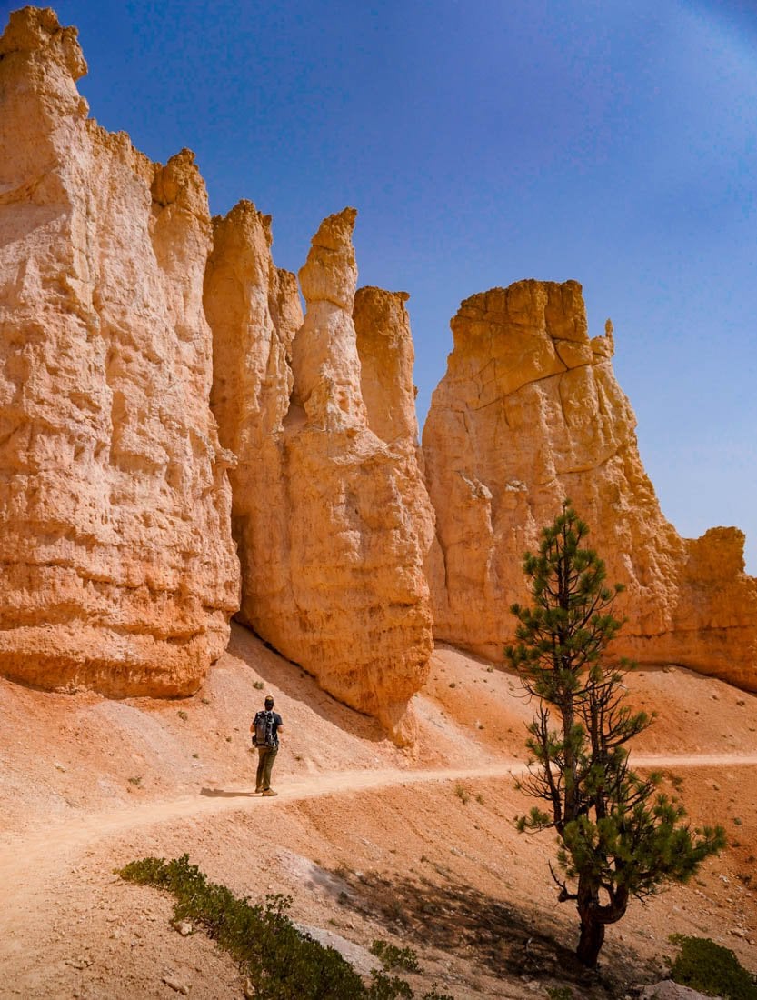
What to Expect Along the Fairyland Loop Trail
Assuming you’ll start at Fairyland Point, you can either hike clockwise, which heads down below the rim of the canyon amongst the hoodoos, or counter-clockwise along the Rim Trail, which (surprise!) follows the rim and overlooks the canyon’s bowl and its colorful hoodoos below.
So, should you hike the Fairyland Loop clockwise or counterclockwise?
It depends! While the Rim Trail is inarguably stunning, it’s also way more crowded than the Fairyland portion of the trail inside the canyon. Plus, the best part of the trail is when you’re down in the magical scenery of the canyon, snaking past the vibrant hoodoos, as they soar overhead.

So would you rather front load your hike with awesomeness or save the best for last? Totally up to you!
We chose to go clockwise and would highly recommend- gimme the good stuff first!
Note: If you start from Sunrise Point, instead, the opposite of what I said above is true- you’ll drop down into the canyon if you hike counterclockwise or can kick off with the Rim Trail if you hike clockwise. Pick your poison!
Assuming you start clockwise from Fairyland Point, you’ll follow several switchbacks downhill, for about 1.3 miles, as you slowly drop deeper and deeper into the canyon.
The trail is super easy to follow, with no junctions along the way until you hit Sunrise Point 5.5 miles in, but be careful nonetheless. The path is made of a crumbly dirt/sand material and can be quite slippery, especially on the steep parts- so bring along a pair of decent hiking shoes, like Tevas (for the ladies and the fellows) if you’re hiking in the summer and boots (for the ladies and the fellows) if you’re hiking in the cooler months for better traction.

For the next several miles, you’ll continuously climb up and down rolling hills, weaving around the hoodoos, in what feels like a fairytale land. The further along you go, the more spectacular the scenery gets, with wispy pine trees and striated ridges of carved rock surrounding you.
Keep an eye out for a little spur trail, around 3.7 miles into the trail- you’ll follow this 0.1 miles to the south to see the Tower Bridge, a famous hoodoo formation that’s eroded away to resemble the London Bridge!
From here, you’ll start your slow climb up to Sunrise Point, with the trail rising about 800 feet to the canyon’s rim over the course of a mile and a half. If you haven’t seen the view over the canyon yet from Sunrise Point, it’s definitely worth a stop- it’s one of the most stunning overlooks in the park!

The last couple of miles are along the Rim Trail, which has some minor inclines but is otherwise blessedly flat. And while the hoodoos feel slightly less grand when you view them from above, the panoramic views along the trail are still breathtaking. About six and a half miles in, the trail will start sloping downhill and, before you know it, you’ll be back at the parking lot where you started.
Can You Camp Along the Fairyland Loop Trail?
To preserve the incredible landscapes in Bryce, camping is fairly limited, with no backpacking options along the trail itself. You can learn more about the available backcountry campsites in the park here, though.
If you’re still interested in camping in the park, you can either camp at the North Campground, which is a 12 minute walk to Sunrise Point or the Sunset Campground, which is a 15 minute walk (find out more here).

I hope you find the Fairyland Loop Trail just as magical as I did. Do you have any questions about the hike? Or did I miss any hot tips about the trail? Drop them down into the comments below!
Thank you for reading our post! Check out our latest stories here and follow us on Instagram (@JustinAndJess_), YouTube, TikTok, or on Facebook to see what we’re up to next!
